Update February 2024
On January 5, 2024, the Town of Billerica, in conjunction with the Town’s Consultant, VHB, submitted the 100% Design Submittal to the Massachusetts Department of Transportation. This Submittal was the result of extensive engineering and design work based on comments received from MassDOT on the 25% and 75% Submittal, comments received from the public at the Public Hearing, and from field investigation at multiple locations.
The Project was filed with the MEPA office on February 15, 2024. Notice of availability of the Expanded Environmental Notification Form (EENF) was published in the February 23, 2024 edition of the Environmental Monitor (see EEA No. 16801). The EENF as well as the Proposed Environmental Impact Report (PEIR) can be downloaded directly from the Environmental Monitor website. Public comments are due to the MEPA office by March 25, 2024. Please submit any comments in writing to the MEPA Reviewer, Eva Vaughn: Eva.Vaughan@mass.gov.
The Town is currently working on securing the right of way and amendments to environmental permitting. The project is currently slated to bid in 2024.
Background
The Town of Billerica has been working over two decades to advance construction of the Yankee Doodle Bike Path throughout town. The construction of Phase 1 of the bikeway will connect the Town of Billerica regionally from the center of town, to the Minuteman Bikeway in Bedford, via the Narrow Gauge Bikeway. The completion of this section would provide an alternative mode transportation corridor from Billerica to Arlington, with connections to many other surrounding communities. The addition of this approximately 4 mile bike path to the community will provide a handicapped accessible link between educational, recreational and conservation areas in the southern portion of the Town.
As part of the design, the Town’s Consultant, VHB, has conducted an Alternative Analysis for the bike path alignment.
The purpose of this analysis is to evaluate various path alignments and to develop a report for the Yankee Doodle Bike Path Committee to use as a tool to select a preferred path alignment. The locations where this analysis was completed were: at the northern end of the project, at a parcel currently owned by the Cabot Corporation, where the abandoned rail bed intersects with Route 3; and at the southern end of the project. For the purposes of the analysis, the project has been divided into 4 sections.
- Section 1 extends from the Billerica High school to Richardson Street.
- Section 2 extends from Richardson Street to Middlesex Turnpike.
- Section 3 extends from Middlesex Turnpike to just north of Route 3.
- Section 4 extends from Route 3 to the Bedford Town line.
In February 2015, the Town submitted the Project Initiation Form (PIF) to MassDOT to request funding through the State and Federal Transportation Improvement Programs.
In July 2016, the Town submitted the 25% Design Submittal, 25% Design Appendices, 25% Design Plans and 25% Right of Way Plans to MassDOT. The path cross section will consist of a 10-foot wide asphalt shared use path (SUP) with two foot shoulders, for a total width of 14 feet. Included in the project is the construction of a 950-foot long boardwalk; a 30-foot high pedestrian ramp structure; drainage crossings; four roadway crossings with RRFB’s; advance roadway signage and pavement markings; and a four car parking lot and trailhead at Middlesex Turnpike.
In February 2018, the Town submitted the 25% Design Submittal, 25% Design Plans, 25% Corridor Design to Mass DOT.
A design public hearing was held on October 2, 2019 to provide the public with an opportunity to become fully acquainted with the project. Please see below for a copy of the presentation, handout, and plans presented at the hearing.
In August 2022, the Town submitted the 75% Design Submittal, along with the 1st Structural Bridge Design Submittal, to the Massachusetts Department of Transportation.
he purpose of this project is to improve vehicular and pedestrian safety and improve traffic operations through the project corridor. The project locus map is shown on the Construction Plans below. The proposed project consists of minor widening and resurfacing of Boston Road (Route 3A) from Danforth Village to Simmons Lane. The travel lanes will be reduced in the northern half of the project from 4 lanes to 3, which will include a center left turn lane. A new traffic signal will be installed at the intersection of Boston Road and Good Street. Two flashing pedestrian beacons will be installed at Heritage Road for the Marshall Middle School. The work will include Heritage Road from Boston Road to Mount Vernon Avenue and 600 feet of Good Street from Boston Road. Bicycle accommodations consisting of a 5’ bicycle lane or a shared use path will be provided in accordance with applicable design guides.
The Project was awarded to J. Tropeano, Inc. in June 2022.
Construction Start: Summer 2022
Construction Complete: Fall 2026
Project Background
On October 9, 2009, the Town received approval from MassDOT’s Project Review Committee for eligibility for Federal Aid funding for this project. the Town was responsible for the cost of the engineering design, environmental permitting, and any Right-of-Way acquisitions and/or easements necessary for the implementation of the project. MassDOT, through a combination of State and Federal funding, will be responsible for funding the construction cost of the project, with the exception of certain non-participating items.
Design began in 2014, starting with field survey of the project area.
A Virtual Design Public Hearing will be published on Wednesday, September 30, 2020 on the MassDOT Public Hearings website to present the design for the proposed Boston Road Rehabilitation Project in Billerica, MA. The purpose of this hearing is to provide the public with the opportunity to become fully acquainted with the proposed Boston Road Rehabilitation project. All views and comments submitted in response to the hearing will be reviewed and considered to the maximum extent possible.
Newport Construction Corp. has been awarded a MassDOT Contract to mill and pave Boston Road (Route 3A) from the south end of the bridge over the Shawsheen River in Billerica to Birch Crest Street in Burlington. The project also includes areas of sidewalk replacement, new curb ramps, and traffic signal upgrades. Sidewalk, driveway, curb ramp excavation and installation will occur in the early stages of this project. Traffic signal upgrades will be completed later in 2024. The milling and paving portion of the project will occur in 2025.
The Project was awarded to Newport Construction Corporation
Construction start date: December 2023
Construction end date: November 2025
Update Winter of 2025:
After many revisions to the 100% Design Submittal, Massachusetts Department of Transportation has requested the Final Design Submission. Bidding Documents are being finalized and will be ready when the project is advertised. Project ad date is set for April 12, 2025.
On July 31, 2023, The Town of Billerica and in conjunction with the Town’s Consultant, BETA Group, submitted the 100% Design Submittal to the Massachusetts Department of Transportation. This submittal was the result of extensive engineering and design work based on comments from MassDOT on the 25% and 75% submittal, comments received from the abutters at the Public Hearing, and from field investigation.
Scope of work:
Intersection Improvements Project at Boston Road, Lexington Road, and Glad Valley Drive (the Project) along an approximately 3,840-foot (0.7 miles) stretch of Boston Road (Route 3A) centrally located in Billerica, Massachusetts. The Boston Road corridor and the intersections of Lexington Road and Glad Valley Drive have safety and operational deficiencies which require improvements for safe and efficient operation for all users, including motor vehicles, bicyclists, and pedestrians. While road work is being performed the Town will also replace the water main that runs along the project length.
Construction on Phase 3 of the Middlesex Turnpike Roadway Improvement Project is ongoing. The project will be completed in sections as shown on the Schedule Plans below. During the project, two-way travel along Middlesex Turnpike will be in effect before 9:00 am and after 2:00 pm. Between 9:00 am and 2:00 pm, police details will limit traffic around the work crews to one travel lane at a time. Motorists driving through the corridor during the midday should expect a delay in travel time.
Phase 3 is the last of a multi-phase, multi-year program to improve traffic through the Tri-Town corridor linking Burlington, Bedford and Billerica. The limits of this project are from Crosby Drive/Plank Street in Bedford to Manning Road in Billerica. Similar to the other phases of the project, Middlesex Turnpike will be widened to two lanes in each direction with protected left turn lanes at all driveways. In addition, new traffic control signals will be installed at Oak Park Drive in Bedford and 900 Middlesex Turnpike, Lexington Road, and Manning Road in Billerica. There will be bike lanes and sidewalks along both sides of the roadway. Utility poles will be relocated to accommodate the widened cross section and new LED’s street lights will be installed. Significant work will take place to widen the roadway at the Shawsheen River. The project is expected to be complete by December 2024.
Below please find our 2025 Paving & Pavement Preservation Road Work List that shows the repair method scheduled on each road. This list is provided for informational purposes only, is not all inclusive, and is subject to change. The actual work to be performed may deviate based on a number of factors, such as funding, environmental permitting, scheduling, etc. All abutters will be contacted in advance of the work and will be provided additional details regarding the specific work on their street. Please contact the DPW Engineering Division for any questions.
| ROAD | FROM | TO | REPAIR METHOD |
|---|---|---|---|
| ALPINE ST | BOSTON RD | CHELMSFORD TL | FOG SEAL W/ CRACK SEAL |
| ANDOVER RD | BOSTON RD | ALLEN RD | DOUBLE MICRO W/ CRACK SEAL |
| ANDOVER RD | NEWPORT DR | WHIPPLE RD | MILL AND OVERLAY – 1.5″ |
| BRIDGE ST | TREBLE COVE RD | NEW FOSTER AVE | FOG SEAL W/ CRACK SEAL |
| BRIDGE ST | NEW FOSTER AVE | BRIDLE RD | MILL AND OVERLAY – 1.5″ |
| BRIDGE ST | BRIDLE RD | BOSTON RD | FOG SEAL W/ CRACK SEAL |
| CANTERBURY ST | MIDDLESEX TPK | YALE ST | RECLAMATION |
| FLOYD ST | BOSTON RD | SCHOOL ENTRANCE | MILL AND OVERLAY – 1.5″ |
| GEORGE BROWN ST | SALEM RD | PUMP STA ACCESS RD | DOUBLE MICRO W/ CRACK SEAL |
| GEORGE BROWN ST | PUMP STA ACCESS RD | WHIPPLE RD | MILL AND OVERLAY – 1.5″ |
| HIGH ST | BRIDGE ST | MOUNT PLEASANT | FOG SEAL W/ CRACK SEAL |
| LEXINGTON RD | BOSTON RD | BEDFORD TL | MILL AND OVERLAY – 1.5″ |
| LOWELL ST | COLSON ST | BOSTON RD | MILL AND OVERLAY – 1.5″ |
| MANNING RD | LEXINGTON RD | PAVEMENT CHANGE | MILL AND OVERLAY – 1.5″ |
| MIDDLESEX TPKE | NEAR CONCORD RD | PEARL RD | MILL AND OVERLAY – 1.5″ + REPLACE SWAND CURB |
| MOUNT PLEASANT ST | HIGH ST | ROGERS ST | FOG SEAL W/ CRACK SEAL |
| OAK ST | POND ST | SHELDON ST | FOG SEAL W/ CRACK SEAL |
| ORCHARD RD | MIDDLESEX CC ENT | BEDFORD TL | FOG SEAL W/ CRACK SEAL |
| ROGERS ST | FRANKLIN ST | HIGH ST | FOG SEAL W/ CRACK SEAL |
| SCHOOL HOUSE LN | WYMAN RD | LEXINGTON RD | FOG SEAL W/ CRACK SEAL |
| SHELDON ST | HIGH ST | TEWSBURY TL | FOG SEAL W/ CRACK SEAL |
| TREBLE COVE RD | CHARLES ANNA LN | OLD TREBLE COVE RD | FOG SEAL |
| WATER ST | MICOZZI WAY | MIDDLESEX TPKE | RECLAMATION |
| YALE ST | CANTERBURY ST | MICOZZI WAY | RECLAMATION |
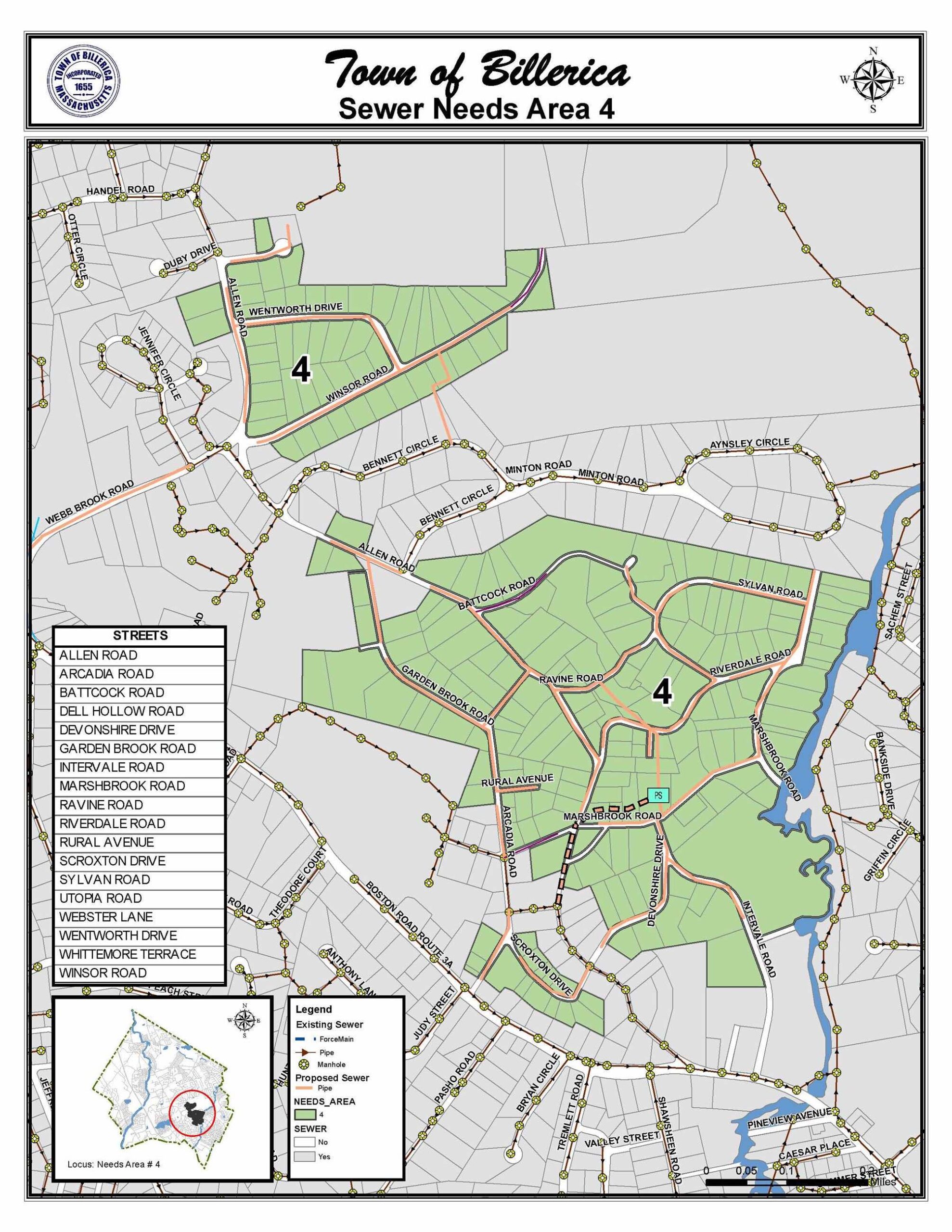
Sewer Contract 37 is located in the Webb Brook and Allen Road neighborhoods. BETA Group is currently designing the sewer for this area, so that we can incorporate a dry sewer main on Allen Road into the Allen Road Reconstruction TIP project. The sewer construction for this area will follow the Town’s master plan for sewerage.
The roads included in this contract area are Allen Road, Battcock Road, Ravine Road, Dell Hollow Road, Sylvan Road, Riverdale Road, Whittemore Terrace, Intervale Road, Marshbrook Road, Devonshire Drive, Scroxton Drive, Arcadia Road, Rural Avenue, Garden Brook Road, Webster Lane, Wentworth Drive, and Winsor Road. A project locus map is shown below.

Flowing Towards Resilience: Climate Change and Hydraulic Capacity of Culverts in Billerica, MA
We’re excited to announce that we have received grant funding for a Culvert Assessment Project! This project aims to enhance our community’s climate resiliency and builds upon the Stormwater Asset Management Project completed in 2022-2023. We will be evaluating culverts (pipes that convey streams across roadways) to determine if the culvert is undersized and cannot handle the stream flow, which can lead to flooding. By assessing our culverts, we can identify areas for improvement and investment, providing safer and more sustainable infrastructure for all residents.
Our own Stormwater Engineer, Christina Papadopoulos, attended the MVP grant announcement by Governor Healey in Leominster on August 1, 2024.
Healey-Driscoll Administration Awards $52 Million in Climate Resiliency Funding to Communities
Project Overview
Funding Source: FY2025 Municipal Vulnerability Preparedness (MVP) Action Grant
Total Budget: $129,500
Timeline: September 2024 – June 2025
This project is intended to evaluate higher-risk culverts within the Town of Billerica. This planning effort will build on the Town’s Stormwater Asset Management Program (AMP), which included an initial condition assessment of Billerica’s 220+ culverts throughout the Town. The results of the 2023 AMP show that some culverts are no longer functioning as designed or are submerged due to high water levels, maintenance issues such as beaver dams or debris, and changing land use and weather patterns that have increased stormwater runoff. This can lead to expedited culvert deterioration, local flooding, and instability of natural stream channels.
This project will provide additional information on submerged and other high priority culverts to evaluate existing culvert condition. (Click here for a map of culverts that were submerged during the AMP culvert assessments.) An analysis will be completed to evaluate and rank consequence of a culvert failure (e.g., failure of a larger culvert in a more heavily trafficked area would affect the community more than a smaller culvert on a rural road) as well as identify areas with high ecological restoration potential. We will also prioritize locations in Town where inland flooding is a regular occurrence. 40 culverts of concern will be selected for further study.
For these 40 culverts, we will use a modeling program to understand which culverts are “undersized” (meaning the culvert restricts natural stream flows, particularly during floods). Additional field investigations will be conducted to assess the condition and characteristics of these culverts and stream conditions. We will utilize a submersible drone to see underwater portions of culverts.
Examples of culverts in Billerica that were submerged during the AMP field assessments.
The Project will create a roadmap with recommendations for the Town to address undersized culverts, culverts located in priority areas, and areas where culvert replacement would provide significant community benefit. We will develop conceptual designs for 5 culverts that should be replaced. Culvert replacement projects are always costly, and this study will help the Town pursue additional grant funding for design and construction.